Geolocate

Boley topographic map

Interactive map

Click on the map to display elevation.

About this map

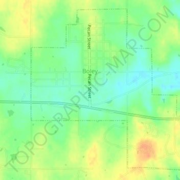
Name: Boley topographic map, elevation, terrain.

Location: Boley, Okfuskee County, Oklahoma, 74829, United States (35.47839 -96.49452 35.50282 -96.46296)

Average elevation: 896 ft

Minimum elevation: 840 ft

Maximum elevation: 958 ft

Other topographic maps

Click on a map to view its topography, its elevation and its terrain.

Paden

United States > Oklahoma > Okfuskee County

Paden, Okfuskee County, Oklahoma, United States

Average elevation: 978 ft

Welty

United States > Oklahoma > Okfuskee County

Welty, Okfuskee County, Oklahoma, United States

Average elevation: 745 ft

Clearview

United States > Oklahoma > Okfuskee County

Clearview, Okfuskee County, Oklahoma, United States

Average elevation: 823 ft

Okemah

United States > Oklahoma > Okfuskee County

Okemah, Okfuskee County, Oklahoma, 74859, United States

Average elevation: 869 ft

Bearden

United States > Oklahoma > Okfuskee County

Bearden, Okfuskee County, Oklahoma, United States

Average elevation: 863 ft