Geolocate

Luck topographic map

Click on the map to display elevation.

About this map

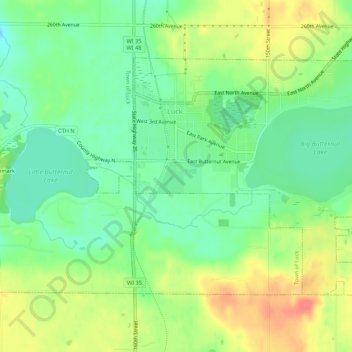
Name: Luck topographic map, elevation, terrain.

Location: Luck, Polk County, Wisconsin, United States (45.55513 -92.49622 45.58062 -92.44233)

Average elevation: 1,243 ft

Minimum elevation: 1,161 ft

Maximum elevation: 1,352 ft

Polk County trails, hiking, mountain biking, running and outdoor activities

Other topographic maps

Click on a map to view its topography, its elevation and its terrain.

Mackie Lake

United States > Wisconsin > Polk County > Town of McKinley

Average elevation: 1,191 ft

Tula Lake

United States > Wisconsin > Polk County

Average elevation: 1,158 ft

Gear up for your next adventure:

🪄Magnetic Compass - Accurate compass for navigation
📱Solar Portable Charger - Solar power bank for charging devices off‑grid
🪶Trail Camera - Capture wildlife on your hikes
🍳Camping Cook Set - Complete cookware for outdoor meals
🩹Survival Bandages - High‑quality bandages for emergencies

As an Amazon Associate, this site earns from qualifying purchases at no extra cost to you.