Geolocate

Radnevo topographic map

Click on the map to display elevation.

About this map

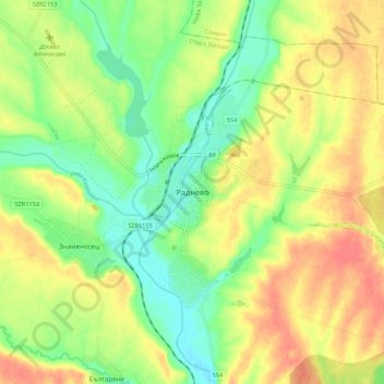
Name: Radnevo topographic map, elevation, terrain.

Location: Radnevo, Stara Zagora, 6260, Bulgaria (42.24905 25.89387 42.32905 25.97387)

Average elevation: 420 ft

Minimum elevation: 335 ft

Maximum elevation: 502 ft

Other topographic maps

Click on a map to view its topography, its elevation and its terrain.

Osetenovo

Bulgaria > Stara Zagora

Average elevation: 2,031 ft

Koprinka

Bulgaria > Stara Zagora

Average elevation: 1,286 ft

Liava Reka

Bulgaria > Stara Zagora

Average elevation: 2,182 ft

Ostra Mogila

Bulgaria > Stara Zagora

Average elevation: 1,650 ft

Zetiovo

Bulgaria > Stara Zagora

Average elevation: 486 ft

Radnevo

Bulgaria > Stara Zagora

Average elevation: 512 ft

Tazha

Bulgaria > Stara Zagora

Average elevation: 3,743 ft

Rozovo

Bulgaria > Stara Zagora

Average elevation: 1,427 ft

Kazanlak

Bulgaria > Stara Zagora

The Bulgarian climate is temperate, with average temperatures from 0 °C (32 °F) to 1.5 °C (34.7 °F) in January, and 21 °C (70 °F) in July. The average altitude is 350 m (1,150 ft).

Average elevation: 1,240 ft

Gear up for your next adventure:

🛰️Satellite Messengers - Emergency SOS and two-way messaging for off-grid adventures
🧤Hiking Gloves - Protective gloves for rugged trails
🔭Stargazing Telescopes - Perfect for camping in low-light pollution areas shown on maps
🧷Carabiner Set - Durable clips for gear attachment
🔥Camping Stove - Portable stove for camping and backcountry cooking

As an Amazon Associate, this site earns from qualifying purchases at no extra cost to you.