Geolocate

Radnevo topographic map

Click on the map to display elevation.

About this map

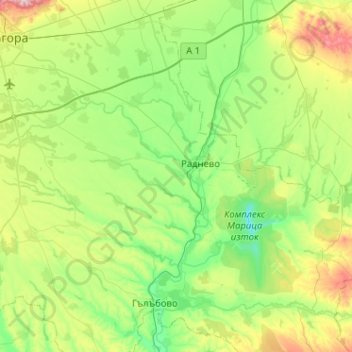
Name: Radnevo topographic map, elevation, terrain.

Location: Radnevo, Stara Zagora, Bulgaria (42.15444 25.68350 42.39629 26.19272)

Average elevation: 512 ft

Minimum elevation: 135 ft

Maximum elevation: 1,516 ft

Other topographic maps

Click on a map to view its topography, its elevation and its terrain.

Stara Zagora

Bulgaria > Stara Zagora

Average elevation: 1,020 ft

Buzludzha

Bulgaria > Stara Zagora > Shipka

Average elevation: 3,930 ft

Stara Zagora

Bulgaria > Stara Zagora

Average elevation: 1,020 ft

Stara Zagora

Bulgaria > Stara Zagora

Average elevation: 1,020 ft

Radnevo

Bulgaria > Stara Zagora

Average elevation: 420 ft

Kaloyanovets

Bulgaria > Stara Zagora

Average elevation: 630 ft

Stara Zagora

Bulgaria > Stara Zagora

Average elevation: 1,020 ft

Gear up for your next adventure:

🏫Relief Map Kits - Hands-on tools for teaching landforms and elevation
🌡️Handheld Weather Meters - Measure wind, temp, and pressure for safe mountain travel
🧭Pro Hiking Compasses - High-accuracy liquid-filled compasses for topographic orientation
❄️Traction Cleats - Prevent slips on icy trails during winter hikes
🧭Outdoor Navigation Book - Learn advanced navigation skills

As an Amazon Associate, this site earns from qualifying purchases at no extra cost to you.