Geolocate

Brondong topographic map

Click on the map to display elevation.

About this map

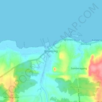
Name: Brondong topographic map, elevation, terrain.

Location: Brondong, Lamongan, East Java, Java, Indonesia (-6.92063 112.23218 -6.84063 112.31218)

Average elevation: 52 ft

Minimum elevation: -10 ft

Maximum elevation: 331 ft

Other topographic maps

Click on a map to view its topography, its elevation and its terrain.

Sidokumpul

Indonesia > East Java > Lamongan > Sambeng

Average elevation: 243 ft

Gondang Dam

Indonesia > East Java > Lamongan > Deketagung

Average elevation: 128 ft

Lamongan

Indonesia > East Java > Lamongan

Average elevation: 98 ft

Gear up for your next adventure:

🩳Quick‑Dry Hiking Shorts - Comfortable and quick‑dry shorts for summer hiking
🧷Carabiner Set - Durable clips for gear attachment
🪶Camping Sleeping Pad - Comfortable sleeping pad for backpacking
📦Gear Storage Bags - Organize and protect outdoor equipment
🧢Outdoor Hiking Hat - Sun protection hat for outdoor explorers

As an Amazon Associate, this site earns from qualifying purchases at no extra cost to you.