Geolocate

Lamongan topographic map

Click on the map to display elevation.

About this map

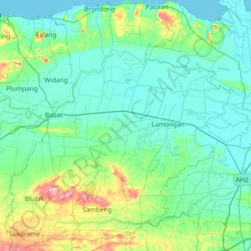
Name: Lamongan topographic map, elevation, terrain.

Location: Lamongan, East Java, Indonesia (-7.38474 112.07256 -6.86113 112.55238)

Average elevation: 98 ft

Minimum elevation: -3 ft

Maximum elevation: 627 ft

Other topographic maps

Click on a map to view its topography, its elevation and its terrain.

Paciran

Indonesia > East Java > Lamongan

Average elevation: 105 ft

Sukodadi

Indonesia > East Java > Lamongan

Average elevation: 20 ft

Paji

Indonesia > East Java > Lamongan

Average elevation: 23 ft

Sungegeneng

Indonesia > East Java > Lamongan

Average elevation: 13 ft

Kembangbahu

Indonesia > East Java > Lamongan

Average elevation: 82 ft

Laren

Indonesia > East Java > Lamongan

Average elevation: 26 ft

Lopang

Indonesia > East Java > Lamongan

Average elevation: 59 ft

Brondong

Indonesia > East Java > Lamongan

Average elevation: 52 ft

Lamongan

Indonesia > East Java > Lamongan

Average elevation: 52 ft

Gear up for your next adventure:

🦶Hiking Gaiters - Keep debris and water out of your boots
🎒Trekking Poles - Sturdy poles for balance and stability on rough terrain
🏔️Mountain Trail Maps - High‑detail maps for popular peaks
🔭Telescopic Hiking Pole - Adjustable pole for hiking stability
🧦Merino Wool Socks - Moisture-wicking, blister-preventing socks for long treks

As an Amazon Associate, this site earns from qualifying purchases at no extra cost to you.