
Make a donation
Gear up for your next adventure:
As an Amazon Associate, this site earns from qualifying purchases at no extra cost to you.
Summit Hill topographic map
Click on the map to display elevation.
Make a donation
Gear up for your next adventure:
As an Amazon Associate, this site earns from qualifying purchases at no extra cost to you.
Summit Hill
According to the U.S. Census Bureau, Summit Hill borough has a total area of 9.1 square miles (23.6 km2), of which 8.7 square miles (22.5 km2) is land and 0.42 square miles (1.1 km2), or 4.54%, is water. Summit Hill is located 6 miles (10 km) southwest of Jim Thorpe and 1 mile south of Lansford. Summit Hill's elevation varies from 1,520 feet (460 m) above sea level in the borough center to 1,620 feet (490 m) at the highest point on Pisgah Mountain to 1,010 feet (310 m) at Mauch Chunk Lake.
Make a donation
Gear up for your next adventure:
As an Amazon Associate, this site earns from qualifying purchases at no extra cost to you.
About this map
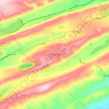
Name: Summit Hill topographic map, elevation, terrain.
Average elevation: 1,207 ft
Minimum elevation: 646 ft
Maximum elevation: 1,680 ft
Carbon County trails, hiking, mountain biking, running and outdoor activities
Make a donation
Gear up for your next adventure:
As an Amazon Associate, this site earns from qualifying purchases at no extra cost to you.
Other topographic maps
Click on a map to view its topography, its elevation and its terrain.
Albrightsville
United States > Pennsylvania > Carbon County > Kidder Township
Average elevation: 1,634 ft
Holiday Poconos
United States > Pennsylvania > Carbon County > Kidder Township
Average elevation: 1,703 ft
Make a donation
Gear up for your next adventure:
As an Amazon Associate, this site earns from qualifying purchases at no extra cost to you.
Lake Harmony
United States > Pennsylvania > Carbon County > Kidder Township > Lake Harmony
Average elevation: 1,864 ft
Beltzville State Park - Parking Lot B
United States > Pennsylvania > Carbon County > Lehighton
Average elevation: 728 ft
Hickory Run State Park
United States > Pennsylvania > Carbon County > Kidder Township
Average elevation: 1,545 ft
Make a donation
Gear up for your next adventure:
As an Amazon Associate, this site earns from qualifying purchases at no extra cost to you.
Holiday Poconos
United States > Pennsylvania > Carbon County > Kidder Township
Average elevation: 1,703 ft
Lake Harmony
United States > Pennsylvania > Carbon County > Kidder Township > Lake Harmony
Average elevation: 1,808 ft
Albrightsville
United States > Pennsylvania > Carbon County > Kidder Township
Average elevation: 1,634 ft
Make a donation
Gear up for your next adventure:
As an Amazon Associate, this site earns from qualifying purchases at no extra cost to you.
Germans
United States > Pennsylvania > Carbon County > East Penn Township > Germans
Average elevation: 781 ft
Holiday Poconos
United States > Pennsylvania > Carbon County > Kidder Township
Average elevation: 1,703 ft