
Kirchheim topographic map
Click on the map to display elevation.
Kirchheim
Kirchheim liegt am Rand der Eifelhöhen. In der Nähe liegen die Städte Rheinbach und Bad Münstereifel.
About this map
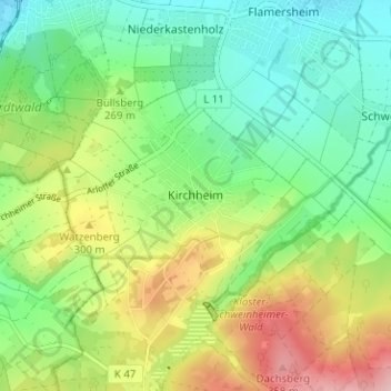
Name: Kirchheim topographic map, elevation, terrain.
Average elevation: 860 ft
Minimum elevation: 640 ft
Maximum elevation: 1,240 ft
Other topographic maps
Click on a map to view its topography, its elevation and its terrain.
Frauenberg
Deutschland > Nordrhein-Westfalen > Kreis Euskirchen > Euskirchen
Average elevation: 531 ft
Kuchenheim
Deutschland > Nordrhein-Westfalen > Kreis Euskirchen > Euskirchen
Average elevation: 568 ft