
Kuchenheim topographic map
Click on the map to display elevation.
About this map
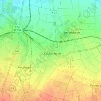
Name: Kuchenheim topographic map, elevation, terrain.
Average elevation: 568 ft
Minimum elevation: 495 ft
Maximum elevation: 650 ft
Other topographic maps
Click on a map to view its topography, its elevation and its terrain.
Wißkirchen
Deutschland > Nordrhein-Westfalen > Kreis Euskirchen > Euskirchen
Average elevation: 653 ft
Am Kesselberg
Deutschland > Nordrhein-Westfalen > Kreis Euskirchen > Euskirchen
Average elevation: 856 ft
Kessenich
Deutschland > Nordrhein-Westfalen > Kreis Euskirchen > Euskirchen > Kessenich
Average elevation: 518 ft
Kirchheim
Deutschland > Nordrhein-Westfalen > Kreis Euskirchen > Euskirchen
Kirchheim liegt am Rand der Eifelhöhen. In der Nähe liegen die Städte Rheinbach und Bad Münstereifel.
Average elevation: 860 ft
Kuchenheim
Deutschland > Nordrhein-Westfalen > Kreis Euskirchen > Euskirchen
An der Südseite des Ortes stand seit 1467 auf einer kleinen Anhöhe (genannt Schießberg, weil man vonseiten der Sebastianus-Schützen drei Schüsse zu Ehren der Dreifaltigkeit abfeuerte, wenn an dem Prozessionskreuz der Segen erteilt worden war) ein Kreuz aus grauem Sandstein, von dem Leheninhaber der oberen…
Average elevation: 574 ft