Geolocate

Buckingham topographic map

Click on the map to display elevation.

About this map

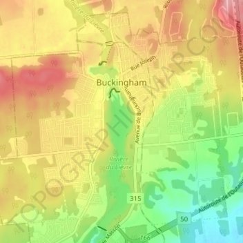
Name: Buckingham topographic map, elevation, terrain.

Location: Buckingham, Gatineau, Outaouais, Quebec, Canada (45.55941 -75.45234 45.59912 -75.38932)

Average elevation: 407 ft

Minimum elevation: 190 ft

Maximum elevation: 610 ft

Other topographic maps

Click on a map to view its topography, its elevation and its terrain.

Parc de la Cité

Canada > Quebec > Gatineau

Average elevation: 190 ft

Lac Beauchamp

Canada > Quebec > Gatineau

Average elevation: 184 ft

Pink Lake

Canada > Quebec > Gatineau

Average elevation: 502 ft

Boisé de l'étrier

Canada > Quebec > Gatineau

Average elevation: 184 ft

Gear up for your next adventure:

🪶Multi‑Purpose Knife - Useful blade for camp and trail
📷Action Cameras - Rugged cameras to document your journeys across rugged terrain
🧦Hiking Socks - Comfortable socks to prevent blisters on long hikes
🏔️Mountain Trail Maps - High‑detail maps for popular peaks
🌐World Map Poster - Decorative world maps with topographic info

As an Amazon Associate, this site earns from qualifying purchases at no extra cost to you.