
Make a donation
Gear up for your next adventure:
As an Amazon Associate, this site earns from qualifying purchases at no extra cost to you.
Neueibau topographic map
Click on the map to display elevation.
Make a donation
Gear up for your next adventure:
As an Amazon Associate, this site earns from qualifying purchases at no extra cost to you.
Neueibau
Neueibau befindet sich einen Kilometer südwestlich von Eibau an der S 142 zwischen Neugersdorf und Leutersdorf. Die 92 ha große Flur des Dorfes erstreckt sich beiderseits des Leutersdorfer Wassers (Leutersdorfer Bach) im Oberlausitzer Bergland. Östlich von Hetzwalde treffen sich hier der östlich gelegene, ehemals gehölzbestandene Hofebusch, der bis weit über die jetzige Neueibauer Höhe (415 m) herabreichte, und der westlich gelegene, ehemals gehölzbestandene Lehnbusch, welcher mit dem größeren Altgersdorfer Waldgebiet in Verbindung stand.
Make a donation
Gear up for your next adventure:
As an Amazon Associate, this site earns from qualifying purchases at no extra cost to you.
About this map
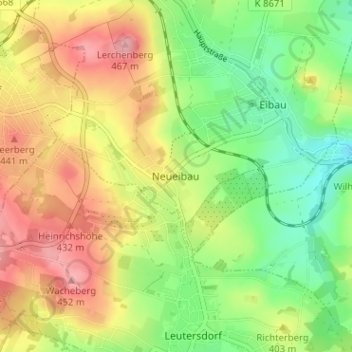
Name: Neueibau topographic map, elevation, terrain.
Average elevation: 1,289 ft
Minimum elevation: 1,102 ft
Maximum elevation: 1,499 ft
Make a donation
Gear up for your next adventure:
As an Amazon Associate, this site earns from qualifying purchases at no extra cost to you.
Other topographic maps
Click on a map to view its topography, its elevation and its terrain.