Geolocate

Constappel topographic map

Click on the map to display elevation.

About this map

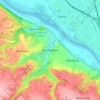
Name: Constappel topographic map, elevation, terrain.

Location: Constappel, Klipphausen, Meissen, Saxony, 01640, Germany (51.08558 13.54481 51.12558 13.58481)

Average elevation: 518 ft

Minimum elevation: 318 ft

Maximum elevation: 840 ft

Other topographic maps

Click on a map to view its topography, its elevation and its terrain.

Nossen

Germany > Saxony > Meißen

Average elevation: 797 ft

01468

Germany > Saxony > Meißen > Moritzburg

Average elevation: 594 ft

Brettmühlenteich

Germany > Saxony > Meißen > Tauscha

Average elevation: 509 ft

Sörnewitz

Germany > Saxony > Meißen > Coswig

Average elevation: 420 ft

Riesa

Germany > Saxony > Meißen

Average elevation: 367 ft

Gear up for your next adventure:

🎒Hydration Pack - Hands‑free water reservoir for long hikes
🧯Emergency Survival Kit - All‑in‑one survival essentials for the backcountry
🔭Telescopic Hiking Pole - Adjustable pole for hiking stability
🥩Freeze-Dried Meals - Nutritious and lightweight food for remote expeditions
🪄Magnetic Compass - Accurate compass for navigation

As an Amazon Associate, this site earns from qualifying purchases at no extra cost to you.