Geolocate

Riesa topographic map

Click on the map to display elevation.

About this map

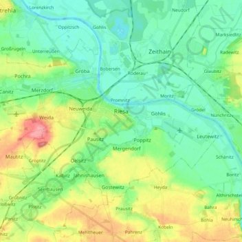
Name: Riesa topographic map, elevation, terrain.

Location: Riesa, Meissen, Saxony, Germany (51.25959 13.20312 51.33866 13.38800)

Average elevation: 367 ft

Minimum elevation: 285 ft

Maximum elevation: 541 ft

Other topographic maps

Click on a map to view its topography, its elevation and its terrain.

Meissen

Germany > Saxony > Meißen

Average elevation: 531 ft

Niederstößwitz

Germany > Saxony > Meißen > Käbschütztal

Average elevation: 627 ft

Mauna

Germany > Saxony > Meißen > Käbschütztal > Krögis

Average elevation: 673 ft

Constappel

Germany > Saxony > Meißen

Average elevation: 518 ft

Kleinprausitz

Germany > Saxony > Meißen > Käbschütztal

Average elevation: 666 ft

Neurobschütz

Germany > Saxony > Meißen > Robschütz

Average elevation: 673 ft

Brettmühlenteich

Germany > Saxony > Meißen > Tauscha

Average elevation: 509 ft

Nossen

Germany > Saxony > Meißen > Nossen

Average elevation: 896 ft

Streumen

Germany > Saxony > Meißen > Streumen

Average elevation: 335 ft

Gear up for your next adventure:

🥤Water Filter Bottle - All‑in‑one filter bottle for safe hydration
🧣Merino Neck Gaiters - Multi-functional headwear for wind and sun protection
😴Insulated Sleeping Pads - Compact and warm pads for high-elevation camping
🧤Tactile Hiking Gloves - Keep hands warm while operating GPS and smartphone screens
🥇GPS Hiking Watch - Multi‑sport GPS watch with navigation and trail tracking

As an Amazon Associate, this site earns from qualifying purchases at no extra cost to you.