
Make a donation
Gear up for your next adventure:
As an Amazon Associate, this site earns from qualifying purchases at no extra cost to you.
Hurlford topographic map
Click on the map to display elevation.
Make a donation
Gear up for your next adventure:
As an Amazon Associate, this site earns from qualifying purchases at no extra cost to you.
About this map
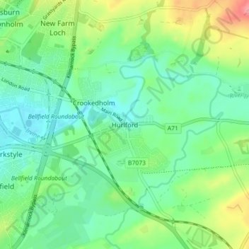
Name: Hurlford topographic map, elevation, terrain.
Location: Hurlford, East Ayrshire, Scotland, KA1 5BZ, United Kingdom (55.58134 -4.47391 55.62134 -4.43391)
Average elevation: 161 ft
Minimum elevation: 72 ft
Maximum elevation: 364 ft
Make a donation
Gear up for your next adventure:
As an Amazon Associate, this site earns from qualifying purchases at no extra cost to you.
Other topographic maps
Click on a map to view its topography, its elevation and its terrain.
Make a donation
Gear up for your next adventure:
As an Amazon Associate, this site earns from qualifying purchases at no extra cost to you.
Make a donation
Gear up for your next adventure:
As an Amazon Associate, this site earns from qualifying purchases at no extra cost to you.
South Dean Plantation
United Kingdom > Scotland > East Ayrshire > Kilmarnock
Average elevation: 210 ft