Geolocate

Millington topographic map

Click on the map to display elevation.

About this map

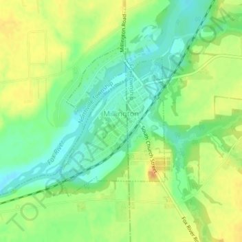
Name: Millington topographic map, elevation, terrain.

Location: Millington, Mission Township, LaSalle County, Illinois, 60537, United States (41.55391 -88.60977 41.57067 -88.59418)

Average elevation: 594 ft

Minimum elevation: 538 ft

Maximum elevation: 653 ft

LaSalle County trails, hiking, mountain biking, running and outdoor activities

Other topographic maps

Click on a map to view its topography, its elevation and its terrain.

Starved Rock

United States > Illinois > LaSalle County

Average elevation: 525 ft

Gear up for your next adventure:

💧Water Purification System - Clean water on the trail with reliable purifiers
🥤Water Filter Bottle - All‑in‑one filter bottle for safe hydration
🗻Climbing Gear Basics - Essential gear for beginner climbers
🧣Merino Neck Gaiters - Multi-functional headwear for wind and sun protection
☀️Outdoor Sunscreen - High protection sunscreen for outdoor activities

As an Amazon Associate, this site earns from qualifying purchases at no extra cost to you.