
Make a donation
Gear up for your next adventure:
As an Amazon Associate, this site earns from qualifying purchases at no extra cost to you.
Lake Garda topographic map
Click on the map to display elevation.
Make a donation
Gear up for your next adventure:
As an Amazon Associate, this site earns from qualifying purchases at no extra cost to you.
Lake Garda
The particularly mild climate favours the growth of some hardy Mediterranean plants, including the olive tree, parasol pine, mediterranean cypress, chinese windmill palm and Canary Island Date Palm. Some hardy citrus trees, such as hardy lemons and satsuma can also be found, which are extremely rare at this latitude (46° North). In ancient times, poets like Catullus wrote about "Lacus Benacus" with its mild climate vivified by the winds. The lake is oriented from north to south towards the Po Valley, so many winds typical of the lake are the result of a difference between lower and higher altitude temperatures. Due to this, winds are generated that descend from the mountains to the plains in the morning and go back to the mountains in the afternoon. The bottleneck formed by the lake basin affects the timing of the winds, many of which happen on a regular daily basis. The winds are all named, most in regional Italian dialect so a single wind may have different names.
Make a donation
Gear up for your next adventure:
As an Amazon Associate, this site earns from qualifying purchases at no extra cost to you.
About this map
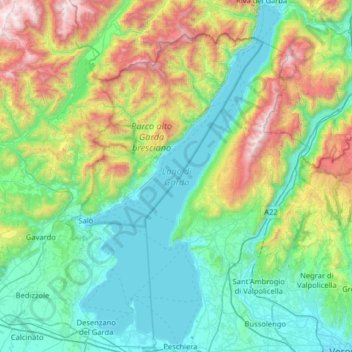
Name: Lake Garda topographic map, elevation, terrain.
Location: Lake Garda, Brescia, Lombardy, Italy (45.44032 10.51091 45.88482 10.87690)
Average elevation: 1,880 ft
Minimum elevation: 180 ft
Maximum elevation: 7,260 ft
Make a donation
Gear up for your next adventure:
As an Amazon Associate, this site earns from qualifying purchases at no extra cost to you.
Other topographic maps
Click on a map to view its topography, its elevation and its terrain.
Make a donation
Gear up for your next adventure:
As an Amazon Associate, this site earns from qualifying purchases at no extra cost to you.
Make a donation
Gear up for your next adventure:
As an Amazon Associate, this site earns from qualifying purchases at no extra cost to you.
Make a donation
Gear up for your next adventure:
As an Amazon Associate, this site earns from qualifying purchases at no extra cost to you.
Make a donation
Gear up for your next adventure:
As an Amazon Associate, this site earns from qualifying purchases at no extra cost to you.
Make a donation
Gear up for your next adventure:
As an Amazon Associate, this site earns from qualifying purchases at no extra cost to you.
Make a donation
Gear up for your next adventure:
As an Amazon Associate, this site earns from qualifying purchases at no extra cost to you.