Geolocate

Nootdorp topographic map

Click on the map to display elevation.

About this map

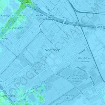
Name: Nootdorp topographic map, elevation, terrain.

Location: Nootdorp, Pijnacker-Nootdorp, South Holland, Netherlands (52.02910 4.37264 52.05405 4.44172)

Average elevation: -7 ft

Minimum elevation: -26 ft

Maximum elevation: 20 ft

Other topographic maps

Click on a map to view its topography, its elevation and its terrain.

Langeraar

Netherlands > South Holland

Average elevation: -10 ft

Broekhuizen

Netherlands > South Holland > Gouda

Average elevation: -3 ft

Ankerpark

Netherlands > South Holland > Leiden

Average elevation: 10 ft

Botlek

Netherlands > South Holland

Average elevation: 10 ft

Middelsluis

Netherlands > South Holland > Numansdorp

Average elevation: 0 ft

Meije

Netherlands > South Holland > Nieuwkoop

Average elevation: -7 ft

Weerestein

Netherlands > South Holland > Hillegom

Average elevation: 0 ft

Weerestein

Netherlands > South Holland > Hillegom

Average elevation: 0 ft

Meijendel

Netherlands > South Holland > Wassenaar

Average elevation: 20 ft

Coepelduynen

Netherlands > South Holland > Katwijk

Average elevation: 13 ft

Het Park

Netherlands > South Holland > Rotterdam

Average elevation: 13 ft

Waalhaven

Netherlands > South Holland > Rotterdam

Average elevation: 10 ft

Gear up for your next adventure:

🪶Thermal Camp Blanket - Extra warmth for cold nights
💧Water Filtration Bottles - Safely drink from streams and lakes while exploring
🪑Portable Camp Table - Compact table for campsite meals
🔌USB Car Charger - Car charger for on‑the‑go power needs
🥩Freeze-Dried Meals - Nutritious and lightweight food for remote expeditions

As an Amazon Associate, this site earns from qualifying purchases at no extra cost to you.