
Valezan topographic map
Click on the map to display elevation.
Valezan
Exposé au sud à 1 200 m d'altitude sur le dôme de Vaugelaz, à 10 min d'Aime et à 15 min de Bourg-Saint-Maurice par la route, Valezan donne sur la vallée de la Tarentaise, du col du Petit-Saint-Bernard à l'est au col de la Madeleine à l'ouest.
About this map
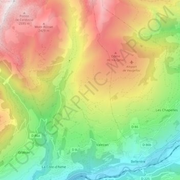
Name: Valezan topographic map, elevation, terrain.
Average elevation: 5,200 ft
Minimum elevation: 2,244 ft
Maximum elevation: 8,901 ft
Other topographic maps
Click on a map to view its topography, its elevation and its terrain.
Plagne Centre
France > Auvergne-Rhône-Alpes > Savoie > La Plagne-Tarentaise
Average elevation: 6,818 ft
Les Chacruets
France > Auvergne-Rhône-Alpes > Savoie > La Plagne-Tarentaise
Average elevation: 3,638 ft
Plan Gagnant
France > Auvergne-Rhône-Alpes > Savoie > La Plagne-Tarentaise
Average elevation: 5,213 ft
Mâcot-la-Plagne
France > Auvergne-Rhône-Alpes > Savoie > La Plagne-Tarentaise
Average elevation: 3,330 ft
Le Ceriseray
France > Auvergne-Rhône-Alpes > Savoie > La Plagne-Tarentaise
Average elevation: 4,596 ft
Belle Plagne
France > Auvergne-Rhône-Alpes > Savoie > La Plagne-Tarentaise
Average elevation: 7,231 ft
Plan d'eau Base de loisirs
France > Auvergne-Rhône-Alpes > Savoie > La Plagne-Tarentaise > Le Villard de Sangot
Average elevation: 3,074 ft
Plagne Villages
France > Auvergne-Rhône-Alpes > Savoie > La Plagne-Tarentaise
Average elevation: 6,903 ft
Plagne Soleil
France > Auvergne-Rhône-Alpes > Savoie > La Plagne-Tarentaise
Average elevation: 6,870 ft
Le Villard de Sangot
France > Auvergne-Rhône-Alpes > Savoie > La Plagne-Tarentaise
Average elevation: 3,556 ft
Les Chacruets
France > Auvergne-Rhône-Alpes > Savoie > La Plagne-Tarentaise
Average elevation: 3,638 ft
Plagne Centre
France > Auvergne-Rhône-Alpes > Savoie > La Plagne-Tarentaise
Average elevation: 6,818 ft