
Le Gothard topographic map
Click on the map to display elevation.
About this map
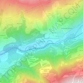
Name: Le Gothard topographic map, elevation, terrain.
Average elevation: 3,504 ft
Minimum elevation: 2,218 ft
Maximum elevation: 5,492 ft
Other topographic maps
Click on a map to view its topography, its elevation and its terrain.
Bellentre
France > Auvergne-Rhône-Alpes > Savoie > La Plagne-Tarentaise
Sous l'impulsion de son maire Auguste Mudry, la station village de Montchavin, à 1 250 m d'altitude, voit le jour en 1972.
Average elevation: 5,591 ft
Mâcot-la-Plagne
France > Auvergne-Rhône-Alpes > Savoie > La Plagne-Tarentaise
La commune de Mâcot-la-Plagne se situe au cœur de la Tarentaise sur le versant de l'ubac et s'étage de 600 à 2 700 mètres d'altitude.
Average elevation: 5,840 ft
Valezan
France > Auvergne-Rhône-Alpes > Savoie > La Plagne-Tarentaise
Exposé au sud à 1 200 m d'altitude sur le dôme de Vaugelaz, à 10 min d'Aime et à 15 min de Bourg-Saint-Maurice par la route, Valezan donne sur la vallée de la Tarentaise, du col du Petit-Saint-Bernard à l'est au col de la Madeleine à l'ouest.
Average elevation: 5,200 ft
Plan d'eau Base de loisirs
France > Auvergne-Rhône-Alpes > Savoie > La Plagne-Tarentaise > Le Villard de Sangot
Average elevation: 3,074 ft
73210
France > Auvergne-Rhône-Alpes > Savoie > La Plagne-Tarentaise > Sangot
Average elevation: 5,794 ft
La Côte-d'Aime
France > Auvergne-Rhône-Alpes > Savoie > La Plagne-Tarentaise
Average elevation: 5,994 ft