
Araci topographic map
Click on the map to display elevation.
Araci
A área do município, segundo o Instituto Brasileiro de Geografia e Estatística, é de 1 495,554 km². Situa-se a 38º58'00” de latitude s e 11º20'00” de longitude w, e com 272 de altitude. Está a uma distância aproximada de 218 quilômetros da capital baiana, por terra e aproximadamente 185 quilômetros em linha reta.
About this map
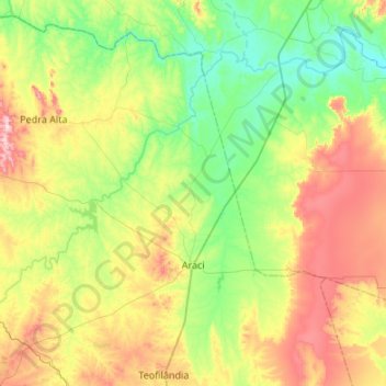
Name: Araci topographic map, elevation, terrain.
Average elevation: 958 ft
Minimum elevation: 449 ft
Maximum elevation: 1,991 ft
Other topographic maps
Click on a map to view its topography, its elevation and its terrain.
Divisa entre cidade alta e cidade baixa
Brasil > Bahia > Região Metropolitana de Salvador > Salvador
Average elevation: 95 ft
Horto
Brasil > Bahia > Região Administrativa Integrada de Desenvolvimento do Polo Petrolina e Juazeiro > Juazeiro
Average elevation: 1,250 ft
Morro da Conceição
Brasil > Bahia > Região Metropolitana de Salvador > Vera Cruz
Average elevation: 72 ft
praça da mogi das cruzes
Brasil > Bahia > Região Metropolitana de Feira de Santana > Feira de Santana
Average elevation: 761 ft
Carnaubeira
Brasil > Bahia > Região Administrativa Integrada de Desenvolvimento do Polo Petrolina e Juazeiro > Casa Nova
Average elevation: 1,463 ft
Praia do Forte
Brasil > Bahia > Região Metropolitana de Salvador > Mata de São João
Average elevation: 16 ft
Reservatório Rosa Dos ventos
Brasil > Bahia > Região Metropolitana de Salvador > Salvador
Average elevation: 52 ft
Parque Municipal Erivaldo Cerqueira
Brasil > Bahia > Região Metropolitana de Feira de Santana > Feira de Santana
Average elevation: 768 ft
Largo Dois de Julho
Brasil > Bahia > Região Metropolitana de Salvador > Salvador
Average elevation: 108 ft
Lagoa dos Dinossauros
Brasil > Bahia > Região Metropolitana de Salvador > Salvador
Average elevation: 59 ft