Geolocate

Richmond topographic map

Click on the map to display elevation.

About this map

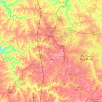
Name: Richmond topographic map, elevation, terrain.

Location: Richmond, Madison County, Kentucky, 40475, United States (37.62352 -84.34202 37.79452 -84.24014)

Average elevation: 922 ft

Minimum elevation: 669 ft

Maximum elevation: 1,060 ft

Madison County trails, hiking, mountain biking, running and outdoor activities

Other topographic maps

Click on a map to view its topography, its elevation and its terrain.

Million

United States > Kentucky > Madison County

Average elevation: 866 ft

Big Mountain

United States > Kentucky > Madison County

Average elevation: 1,037 ft

Richmond

United States > Kentucky > Madison County > Richmond

Average elevation: 876 ft

Gear up for your next adventure:

GPS Sports Watch - GPS watch for running, hiking and training
🗺️NatGeo Topo Maps - High-quality waterproof printed topographic maps of US Parks
🧭Outdoor Navigation Book - Learn advanced navigation skills
🪓Survival Multi‑Tool - Versatile tool for camp and trail tasks
🧦Merino Wool Socks - Moisture-wicking, blister-preventing socks for long treks

As an Amazon Associate, this site earns from qualifying purchases at no extra cost to you.