
Make a donation
Gear up for your next adventure:
As an Amazon Associate, this site earns from qualifying purchases at no extra cost to you.
Cambourne topographic map
Click on the map to display elevation.
Make a donation
Gear up for your next adventure:
As an Amazon Associate, this site earns from qualifying purchases at no extra cost to you.
About this map
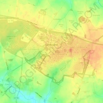
Name: Cambourne topographic map, elevation, terrain.
Average elevation: 207 ft
Minimum elevation: 128 ft
Maximum elevation: 249 ft
Make a donation
Gear up for your next adventure:
As an Amazon Associate, this site earns from qualifying purchases at no extra cost to you.
Other topographic maps
Click on a map to view its topography, its elevation and its terrain.
Shepherd's Way
United Kingdom > England > Cambridgeshire > South Cambridgeshire
Average elevation: 52 ft
Icehouse
United Kingdom > England > Cambridgeshire > South Cambridgeshire > Babraham
Average elevation: 118 ft
Make a donation
Gear up for your next adventure:
As an Amazon Associate, this site earns from qualifying purchases at no extra cost to you.
(no name - just a patch of grass)
United Kingdom > England > Cambridgeshire > South Cambridgeshire > Waterbeach
Average elevation: 20 ft