Geolocate

桑多镇 topographic map

Interactive map

Click on the map to display elevation.

About this map

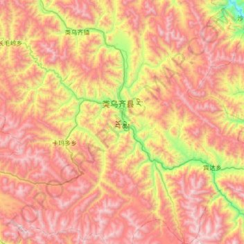
Name: 桑多镇 topographic map, elevation, terrain.

Location: 桑多镇, 类乌齐县, 昌都市, 西藏自治区, 中国 (30.96962 96.48800 31.42951 96.80734)

Average elevation: 14,708 ft

Minimum elevation: 11,171 ft

Maximum elevation: 17,822 ft

Other topographic maps

Click on a map to view its topography, its elevation and its terrain.

卡玛多乡

中国 > 西藏自治区 > 类乌齐县

卡玛多乡, 类乌齐县, 昌都市, 西藏自治区, 中国

Average elevation: 14,849 ft

宾达乡

中国 > 西藏自治区 > 类乌齐县

宾达乡, 类乌齐县, 昌都市, 西藏自治区, 中国

Average elevation: 14,327 ft

吉多乡

中国 > 西藏自治区 > 类乌齐县

吉多乡, 类乌齐县, 昌都市, 西藏自治区, 中国

Average elevation: 14,475 ft

岗色乡

中国 > 西藏自治区 > 类乌齐县

岗色乡, 类乌齐县, 昌都市, 西藏自治区, 中国

Average elevation: 15,118 ft

类乌齐镇

中国 > 西藏自治区 > 类乌齐县

类乌齐镇, 类乌齐县, 昌都市, 西藏自治区, 中国

Average elevation: 14,613 ft