
Gloucester topographic map
Click on the map to display elevation.
About this map
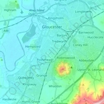
Name: Gloucester topographic map, elevation, terrain.
Location: Gloucester, Gloucestershire, England, United Kingdom (51.80757 -2.30139 51.88522 -2.17726)
Average elevation: 118 ft
Minimum elevation: 13 ft
Maximum elevation: 899 ft
Other topographic maps
Click on a map to view its topography, its elevation and its terrain.
Ruardean Hill
United Kingdom > England > Gloucestershire > Forest of Dean > Drybrook
Average elevation: 669 ft
Stow-on-the-Wold
United Kingdom > England > Gloucestershire > Cotswold District
Average elevation: 535 ft
Lower Slaughter
United Kingdom > England > Gloucestershire > Cotswold District
Average elevation: 525 ft
Alney Island
United Kingdom > England > Gloucestershire > Tewkesbury > Maisemore
Average elevation: 43 ft
Trewsbury Mead
United Kingdom > England > Gloucestershire > Cotswold District
Average elevation: 400 ft
Joyford
United Kingdom > England > Gloucestershire > Forest of Dean > Berry Hill
Average elevation: 617 ft
Jubilee Playing Field & Athletics Track
United Kingdom > England > Gloucestershire > Stroud > Cam > Draycott
Average elevation: 148 ft
Duntisbourne Abbots
United Kingdom > England > Gloucestershire > Cotswold District
Average elevation: 669 ft
Bream Meend
United Kingdom > England > Gloucestershire > Forest of Dean > Bream
Average elevation: 459 ft
Highbury
United Kingdom > England > Gloucestershire > Forest of Dean > Lydney > Allaston
Average elevation: 213 ft
Grange Village
United Kingdom > England > Gloucestershire > Forest of Dean > Littledean
Average elevation: 322 ft
Calcot
United Kingdom > England > Gloucestershire > Cotswold District > Coln Rogers
Average elevation: 495 ft
Bamfurlong
United Kingdom > England > Gloucestershire > Tewkesbury > Staverton
Average elevation: 112 ft
Saunders Green
United Kingdom > England > Gloucestershire > Forest of Dean > Whitecroft
Average elevation: 364 ft
Bakers Hill
United Kingdom > England > Gloucestershire > Forest of Dean > Broadwell
Average elevation: 640 ft
Lydney Hub
United Kingdom > England > Gloucestershire > Forest of Dean > Lydney > Allaston > Tutnalls
Average elevation: 138 ft
Caudle Green
United Kingdom > England > Gloucestershire > Cotswold District > Brimpsfield
Average elevation: 768 ft
Chalford Hill
United Kingdom > England > Gloucestershire > Stroud > Chalford
Average elevation: 574 ft
Newent Woods
United Kingdom > England > Gloucestershire > Forest of Dean > May Hill
Average elevation: 515 ft
Ham
United Kingdom > England > Gloucestershire > Cheltenham > Charlton Kings
Average elevation: 459 ft
Bourton-on-the-Hill
United Kingdom > England > Gloucestershire > Cotswold District
Average elevation: 643 ft
The Lake
United Kingdom > England > Gloucestershire > Cotswold > Upper Slaughter
Average elevation: 650 ft
Hidcote Bartrim
United Kingdom > England > Gloucestershire > Cotswold District > Ebrington
Average elevation: 486 ft
The Pludds
United Kingdom > England > Gloucestershire > Forest of Dean > Ruardean
Average elevation: 558 ft
Joys Green
United Kingdom > England > Gloucestershire > Forest of Dean > Upper Lydbrook
Average elevation: 466 ft
Bushley Muzzard, Brimpsfield
United Kingdom > England > Gloucestershire > Cotswold District > Nettleton > Watercombe
Average elevation: 856 ft
Abbeymead Contour Park
United Kingdom > England > Gloucestershire > Gloucester
Average elevation: 151 ft
Ampney Crucis
United Kingdom > England > Gloucestershire > Cotswold District
Average elevation: 374 ft
Westbury-on-Severn
United Kingdom > England > Gloucestershire > Forest of Dean District
Average elevation: 56 ft
Wigpool Green
United Kingdom > England > Gloucestershire > Forest of Dean District > Puddlebrook > Wigpool Green
Average elevation: 568 ft
Dursley Cross
United Kingdom > England > Gloucestershire > Forest of Dean District > May Hill > Dursley Cross
Average elevation: 413 ft
Broad Campden
United Kingdom > England > Gloucestershire > Cotswold District
Average elevation: 548 ft
Knap House Quarry, Birdlip
United Kingdom > England > Gloucestershire > Cotswold District > Birdlip
Average elevation: 728 ft
Bishop's Cleeve
United Kingdom > England > Gloucestershire > Tewkesbury > Gotherington
Average elevation: 167 ft
Newnham on Severn
United Kingdom > England > Gloucestershire > Forest of Dean
Average elevation: 180 ft