Geolocate

Cartney topographic map

Click on the map to display elevation.

About this map

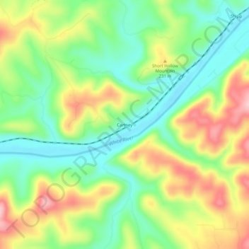
Name: Cartney topographic map, elevation, terrain.

Location: Cartney, Baxter County, Arkansas, United States (36.17451 -92.40238 36.21451 -92.36238)

Average elevation: 600 ft

Minimum elevation: 351 ft

Maximum elevation: 948 ft

Baxter County trails, hiking, mountain biking, running and outdoor activities

Other topographic maps

Click on a map to view its topography, its elevation and its terrain.

Gassville

United States > Arkansas > Baxter County

Average elevation: 656 ft

Salesville

United States > Arkansas > Baxter County

Average elevation: 558 ft

Big Flat

United States > Arkansas > Baxter County

Average elevation: 1,161 ft

Norfork Lake

United States > Arkansas > Baxter County

Average elevation: 741 ft

Briarcliff

United States > Arkansas > Baxter County

Average elevation: 774 ft

Gear up for your next adventure:

🥄Camping Utensil Set - Lightweight utensils for outdoor meals
🌡️Portable Weather Meter - Track weather conditions on the trail
👟Men's Trail Runners - Lightweight footwear for fast-paced exploration and light hiking
🪄Magnetic Compass - Accurate compass for navigation
🔭Telescopic Hiking Pole - Adjustable pole for hiking stability

As an Amazon Associate, this site earns from qualifying purchases at no extra cost to you.