Geolocate

Norfork Lake topographic map

Click on the map to display elevation.

About this map

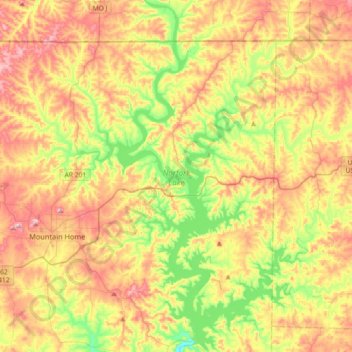
Name: Norfork Lake topographic map, elevation, terrain.

Location: Norfork Lake, Baxter County, Arkansas, United States (36.24020 -92.36390 36.53175 -92.12155)

Average elevation: 741 ft

Minimum elevation: 374 ft

Maximum elevation: 1,138 ft

Baxter County trails, hiking, mountain biking, running and outdoor activities

Other topographic maps

Click on a map to view its topography, its elevation and its terrain.

Three Brothers

United States > Arkansas > Baxter County

Average elevation: 1,060 ft

Monkey Run

United States > Arkansas > Baxter County

Average elevation: 768 ft

Henderson

United States > Arkansas > Baxter County

Average elevation: 633 ft

Midway

United States > Arkansas > Baxter County

Average elevation: 883 ft

Arkana

United States > Arkansas > Baxter County

Average elevation: 614 ft

Cartney

United States > Arkansas > Baxter County

Average elevation: 600 ft

Hopewell

United States > Arkansas > Baxter County

Average elevation: 705 ft

Jordan

United States > Arkansas > Baxter County

Average elevation: 755 ft

Buford

United States > Arkansas > Baxter County

Average elevation: 738 ft

McPhearson

United States > Arkansas > Baxter County

Average elevation: 591 ft

Clarkridge

United States > Arkansas > Baxter County

Average elevation: 787 ft

Old Joe

United States > Arkansas > Baxter County > Old Joe

Average elevation: 604 ft

Gear up for your next adventure:

📻Weather Alert Radios - Stay informed of storm risks while off-the-grid
🖼️Topo Map Wall Art - Decorative topographic prints of famous peaks and regions
🎒Trail Energy Bars - High‑calorie bars for hiking energy
🔥Fast-Boil Camping Stoves - Efficient cooking systems for quick trail meals
🎒Gear Packing Cubes - Organize your backpack efficiently

As an Amazon Associate, this site earns from qualifying purchases at no extra cost to you.