
Deanston topographic map
Click on the map to display elevation.
About this map
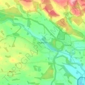
Name: Deanston topographic map, elevation, terrain.
Location: Deanston, Stirling, Scotland, FK16 6AJ, United Kingdom (56.17083 -4.09427 56.21083 -4.05427)
Average elevation: 184 ft
Minimum elevation: 23 ft
Maximum elevation: 456 ft
Other topographic maps
Click on a map to view its topography, its elevation and its terrain.
Loch Lomond and The Trossachs National Park
United Kingdom > Scotland > Stirling
The park straddles the Highland Boundary Fault, which divides it into two distinct regions - lowland and highland - that differ in underlying geology, soil types and topography. The change in rock type can most clearly be seen at Loch Lomond itself, as the fault runs across the islands of Inchmurrin, Creinch,…
Average elevation: 955 ft