Geolocate

Carl topographic map

Click on the map to display elevation.

About this map

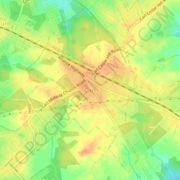
Name: Carl topographic map, elevation, terrain.

Location: Carl, Barrow County, Georgia, United States (33.99121 -83.82909 34.01609 -83.80222)

Average elevation: 1,040 ft

Minimum elevation: 958 ft

Maximum elevation: 1,093 ft

Barrow County trails, hiking, mountain biking, running and outdoor activities

Other topographic maps

Click on a map to view its topography, its elevation and its terrain.

Russell

United States > Georgia > Barrow County

Average elevation: 915 ft

Gear up for your next adventure:

🥾Women's Hiking Boots - Top-rated trail boots with ankle support and superior grip
🌐World Map Poster - Decorative world maps with topographic info
🛠️Backpacking Tool Kit - Essential toolkit for outdoor repairs
🕶️Glacier Sunglasses - Side shields to protect eyes from high-altitude snow glare
🏔️Mountain Trail Maps - High‑detail maps for popular peaks

As an Amazon Associate, this site earns from qualifying purchases at no extra cost to you.