Geolocate

Russell topographic map

Click on the map to display elevation.

About this map

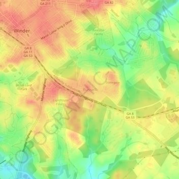
Name: Russell topographic map, elevation, terrain.

Location: Russell, Barrow County, Georgia, 30680, United States (33.95872 -83.72017 33.99872 -83.68017)

Average elevation: 915 ft

Minimum elevation: 787 ft

Maximum elevation: 1,010 ft

Barrow County trails, hiking, mountain biking, running and outdoor activities

Other topographic maps

Click on a map to view its topography, its elevation and its terrain.

Statham

United States > Georgia > Barrow County

Average elevation: 856 ft

Bethlehem

United States > Georgia > Barrow County

Average elevation: 846 ft

Carl

United States > Georgia > Barrow County

Average elevation: 1,040 ft

Auburn

United States > Georgia > Barrow County

Average elevation: 984 ft

Gear up for your next adventure:

🧷Carabiner Set - Durable clips for gear attachment
🧣Hiking Neck Gaiter - Multi‑use neck protection for outdoor weather
🎒Hydration Pack - Hands‑free water reservoir for long hikes
🛠️Backpacking Tool Kit - Essential toolkit for outdoor repairs
📡Handheld GPS Device - Reliable handheld GPS for outdoor navigation

As an Amazon Associate, this site earns from qualifying purchases at no extra cost to you.