Geolocate

Prim topographic map

Click on the map to display elevation.

About this map

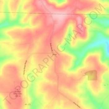
Name: Prim topographic map, elevation, terrain.

Location: Prim, Cleburne County, Arkansas, 72130, United States (35.67397 -92.12848 35.71397 -92.08848)

Average elevation: 1,158 ft

Minimum elevation: 846 ft

Maximum elevation: 1,332 ft

Cleburne County trails, hiking, mountain biking, running and outdoor activities

Other topographic maps

Click on a map to view its topography, its elevation and its terrain.

Higden

United States > Arkansas > Cleburne County

Average elevation: 499 ft

Concord

United States > Arkansas > Cleburne County

Average elevation: 974 ft

Gear up for your next adventure:

📖Nature Tracking Books - Learn to track wildlife and terrain
🦟Ultrasonic Repellers - Create a bug-free zone at your camp or rest stop
🛶Inflatable Kayak - Portable kayak for rivers, lakes, and expeditions
🏕️Tent Footprint - Protect your tent base from wear
🎒Waterproof Dry Bags - Keep your electronics and maps dry inside your pack

As an Amazon Associate, this site earns from qualifying purchases at no extra cost to you.