Geolocate

Higden topographic map

Click on the map to display elevation.

About this map

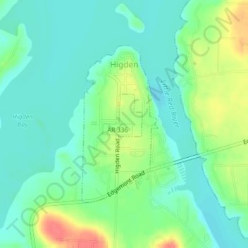
Name: Higden topographic map, elevation, terrain.

Location: Higden, Cleburne County, Arkansas, United States (35.55833 -92.20889 35.57546 -92.19859)

Average elevation: 499 ft

Minimum elevation: 440 ft

Maximum elevation: 630 ft

Cleburne County trails, hiking, mountain biking, running and outdoor activities

Other topographic maps

Click on a map to view its topography, its elevation and its terrain.

Tannenbaum

United States > Arkansas > Cleburne County

Average elevation: 587 ft

Prim

United States > Arkansas > Cleburne County

Average elevation: 1,158 ft

Ida

United States > Arkansas > Cleburne County

Average elevation: 925 ft

Hopewell

United States > Arkansas > Cleburne County

Average elevation: 833 ft

Tumbling Shoals

United States > Arkansas > Cleburne County

Average elevation: 715 ft

Concord

United States > Arkansas > Cleburne County > Concord > Concord

Average elevation: 978 ft

West Pangburn

United States > Arkansas > Cleburne County

Average elevation: 466 ft

Edgemont

United States > Arkansas > Cleburne County

Average elevation: 584 ft

Eden Isle

United States > Arkansas > Cleburne County

Average elevation: 705 ft

Gear up for your next adventure:

🎒Hydration Pack - Hands‑free water reservoir for long hikes
🧭Compass with Lanyard - Easy‑carry compass for navigation
🧴Hand Sanitizer - Keep hands clean while hiking
🪶Camp Gear Gift Set - Perfect gift bundle for outdoor fans
🧺Microfiber Travel Towels - Compact and fast-drying towels for trail use

As an Amazon Associate, this site earns from qualifying purchases at no extra cost to you.