Geolocate

Alice topographic map

Click on the map to display elevation.

About this map

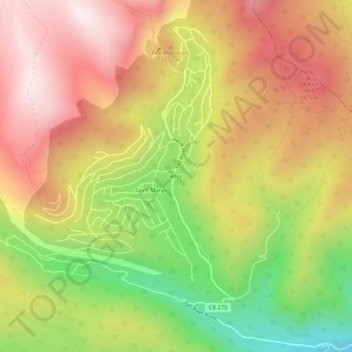
Name: Alice topographic map, elevation, terrain.

Location: Alice, Clear Creek County, Colorado, United States (39.79832 -105.66278 39.83832 -105.62278)

Average elevation: 10,528 ft

Minimum elevation: 9,055 ft

Maximum elevation: 11,726 ft

Clear Creek County trails, hiking, mountain biking, running and outdoor activities

Other topographic maps

Click on a map to view its topography, its elevation and its terrain.

Silver Plume

United States > Colorado > Clear Creek County

Average elevation: 10,190 ft

Empire

United States > Colorado > Clear Creek County

Average elevation: 9,035 ft

Silver Plume

United States > Colorado > Clear Creek County

Average elevation: 10,190 ft

Gear up for your next adventure:

🧣Hiking Neck Gaiter - Multi‑use neck protection for outdoor weather
🧤Hiking Gloves - Protective gloves for rugged trails
🛶Inflatable Kayak - Portable kayak for rivers, lakes, and expeditions
🔦Powerful Headlamps - Ultra-bright hands-free lighting for night navigation
🧭Orienteering Set - Complete compass and map reading kit

As an Amazon Associate, this site earns from qualifying purchases at no extra cost to you.