
Make a donation
Gear up for your next adventure:
As an Amazon Associate, this site earns from qualifying purchases at no extra cost to you.
Floyd Hill Open Space topographic map
Click on the map to display elevation.
Make a donation
Gear up for your next adventure:
As an Amazon Associate, this site earns from qualifying purchases at no extra cost to you.
About this map
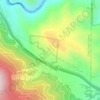
Name: Floyd Hill Open Space topographic map, elevation, terrain.
Average elevation: 8,022 ft
Minimum elevation: 7,100 ft
Maximum elevation: 9,364 ft
Clear Creek County trails, hiking, mountain biking, running and outdoor activities
Make a donation
Gear up for your next adventure:
As an Amazon Associate, this site earns from qualifying purchases at no extra cost to you.
Other topographic maps
Click on a map to view its topography, its elevation and its terrain.
Guanella Pass
United States > Colorado > Clear Creek County
Guanella Pass (elevation 11,669 ft or 3,557 m) is a high mountain pass in central Colorado, in the Rocky Mountains of the western United States.
Average elevation: 11,568 ft
Make a donation
Gear up for your next adventure:
As an Amazon Associate, this site earns from qualifying purchases at no extra cost to you.
Make a donation
Gear up for your next adventure:
As an Amazon Associate, this site earns from qualifying purchases at no extra cost to you.