Geolocate

Cissone topographic map

Click on the map to display elevation.

About this map

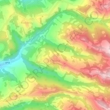
Name: Cissone topographic map, elevation, terrain.

Location: Cissone, Cuneo, Piedmont, Italy (44.55177 8.00549 44.57764 8.04891)

Average elevation: 1,860 ft

Minimum elevation: 1,362 ft

Maximum elevation: 2,339 ft

Other topographic maps

Click on a map to view its topography, its elevation and its terrain.

Bertolini

Italy > Piedmont > Cuneo > Crissolo

Average elevation: 5,531 ft

Monastero

Italy > Piedmont > Cuneo > Mondovì

Average elevation: 1,470 ft

Pianche

Italy > Piedmont > Cuneo

Average elevation: 4,908 ft

Pievetta

Italy > Piedmont > Cuneo

Average elevation: 2,411 ft

Montescotto

Italy > Piedmont > Cuneo > Barge

Average elevation: 2,110 ft

San Bernolfo

Italy > Piedmont > Cuneo > Vinadio

Average elevation: 6,680 ft

Gear up for your next adventure:

🪑Portable Camp Table - Compact table for campsite meals
🚗GPS Dash Cams - Record your scenic drives through mountain passes and canyons
🗃️Trail First Aid Kit - Essential kit for outdoor injuries and emergencies
🥤Water Filter Bottle - All‑in‑one filter bottle for safe hydration
🏕️Family Camping Gear - Essentials for group camping trips

As an Amazon Associate, this site earns from qualifying purchases at no extra cost to you.