Geolocate

Prutz topographic map

Click on the map to display elevation.

About this map
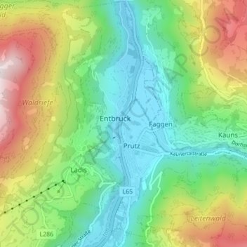
Name: Prutz topographic map, elevation, terrain.

Location: Prutz, Bezirk Landeck, Tyrol, 6522, Austria (47.05780 10.64600 47.10461 10.71278)

Average elevation: 4,163 ft

Minimum elevation: 2,808 ft

Maximum elevation: 6,690 ft

Other topographic maps

Click on a map to view its topography, its elevation and its terrain.

Fisser Höfe

Austria > Tyrol > Bezirk Landeck > Fiss

Average elevation: 4,350 ft

Habigen

Austria > Tyrol > Bezirk Landeck > See

Average elevation: 5,180 ft

Komperdell

Austria > Tyrol > Bezirk Landeck > Serfaus

Average elevation: 6,601 ft

Nasserein

Austria > Tyrol > Bezirk Landeck > Sankt Jakob am Arlberg

Average elevation: 5,584 ft

Sankt Jakob am Arlberg

Austria > Tyrol > Bezirk Landeck

Average elevation: 5,469 ft

Madau

Austria > Tyrol > Bezirk Landeck

Average elevation: 5,840 ft

Pfannknecht

Austria > Tyrol > Bezirk Landeck > Galtür

Average elevation: 8,547 ft

Gand

Austria > Tyrol > Bezirk Landeck > Sankt Jakob am Arlberg

Average elevation: 5,440 ft

Gand

Austria > Tyrol > Bezirk Landeck > Sankt Jakob am Arlberg

Average elevation: 5,440 ft

Tscheyegg

Austria > Tyrol > Bezirk Landeck > Gemeinde Nauders

Average elevation: 7,904 ft

Gear up for your next adventure:

👟Trail Running Shoes - Lightweight shoes for trail runners
🪶Multi‑Purpose Knife - Useful blade for camp and trail
🏔️Mountain Trail Maps - High‑detail maps for popular peaks
🏕️Family Camping Gear - Essentials for group camping trips
☀️Outdoor Sunscreen - High protection sunscreen for outdoor activities

As an Amazon Associate, this site earns from qualifying purchases at no extra cost to you.