
Landrum topographic map
Click on the map to display elevation.
About this map
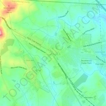
Name: Landrum topographic map, elevation, terrain.
Location: Landrum, Spartanburg County, South Carolina, United States (35.16075 -82.20675 35.19039 -82.15851)
Average elevation: 1,007 ft
Minimum elevation: 866 ft
Maximum elevation: 1,358 ft
Spartanburg County trails, hiking, mountain biking, running and outdoor activities
Other topographic maps
Click on a map to view its topography, its elevation and its terrain.
Croft State Park
United States > South Carolina > Spartanburg County > Pauline
Average elevation: 679 ft
East Spartanburg
United States > South Carolina > Spartanburg County > Spartanburg
Average elevation: 745 ft
East Spartanburg
United States > South Carolina > Spartanburg County > Spartanburg
Average elevation: 745 ft
Spartanburg
United States > South Carolina > Spartanburg County > Spartanburg
Average elevation: 768 ft