Geolocate

Wickford topographic map

Click on the map to display elevation.

About this map

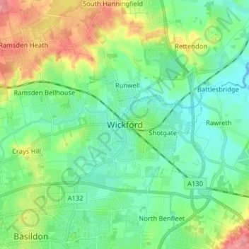
Name: Wickford topographic map, elevation, terrain.

Location: Wickford, Basildon, Essex, England, SS12 9AF, United Kingdom (51.57139 0.48444 51.65139 0.56444)

Average elevation: 89 ft

Minimum elevation: 0 ft

Maximum elevation: 292 ft

Other topographic maps

Click on a map to view its topography, its elevation and its terrain.

Maldon

United Kingdom > England > Essex

Average elevation: 89 ft

Braintree

United Kingdom > England > Essex

Average elevation: 217 ft

Great Baddow

United Kingdom > England > Essex > Chelmsford

Average elevation: 121 ft

Rayleigh

United Kingdom > England > Essex

Average elevation: 121 ft

Ashdon

United Kingdom > England > Essex > Uttlesford > Ashdon

Average elevation: 312 ft

Wivenhoe

United Kingdom > England > Essex > Colchester > Rowhedge

Average elevation: 72 ft

Wivenhoe Woods

United Kingdom > England > Essex > Colchester > Wivenhoe > Rowhedge

Average elevation: 59 ft

Lawford

United Kingdom > England > Essex

Average elevation: 75 ft

Basildon

United Kingdom > England > Essex

Average elevation: 112 ft

River Stour

United Kingdom > England > Essex

Average elevation: 180 ft

Hockley

United Kingdom > England > Essex > Rochford > Hockley

Average elevation: 115 ft

Great Dunmow

United Kingdom > England > Essex > Uttlesford > Great Dunmow

Average elevation: 266 ft

Great Yeldham

United Kingdom > England > Essex > Braintree

Average elevation: 220 ft

Gear up for your next adventure:

🧯Portable Fire Pit - Compact fire pit for camping spots
🧢Outdoor Hiking Hat - Sun protection hat for outdoor explorers
🪑Ultralight Camp Chairs - Portable seating for resting after a long day of mapping
📻Weather Alert Radios - Stay informed of storm risks while off-the-grid
🥇GPS Hiking Watch - Multi‑sport GPS watch with navigation and trail tracking

As an Amazon Associate, this site earns from qualifying purchases at no extra cost to you.