
Di Linh District topographic map
Interactive map
Click on the map to display elevation.
About this map
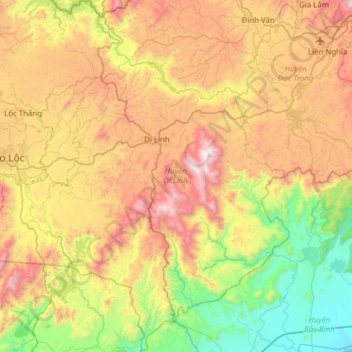
Name: Di Linh District topographic map, elevation, terrain.
Location: Di Linh District, Lâm Đồng Province, Vietnam (11.21516 107.87440 11.82026 108.30678)
Average elevation: 2,388 ft
Minimum elevation: 56 ft
Maximum elevation: 5,912 ft
Other topographic maps
Click on a map to view its topography, its elevation and its terrain.
Đức Trọng District
Đức Trọng District, Lâm Đồng Province, 66000, Vietnam
Average elevation: 3,248 ft
Bản Dơ Tơ Bo
Vietnam > Lâm Đồng Province > Lạc Dương District
Bản Dơ Tơ Bo, Lạc Dương District, Lâm Đồng Province, Vietnam
Average elevation: 4,941 ft
Valley of Love
Vietnam > Lâm Đồng Province > Da Lat City
Valley of Love, Mai Anh Đào, Phường 7, Da Lat City, Lâm Đồng Province, 66100, Vietnam
Average elevation: 4,977 ft
Mont Lang Biang belvédère
Vietnam > Lâm Đồng Province > Lạc Dương District > Lạc Dương
Mont Lang Biang belvédère, Lạc Dương, Lạc Dương District, Lâm Đồng Province, Vietnam
Average elevation: 5,315 ft
Bảo Lộc
Vietnam > Lâm Đồng Province > Bảo Lộc
Bảo Lộc, Lâm Đồng Province, Vietnam
Average elevation: 2,674 ft
Dalat
Vietnam > Lâm Đồng Province > Dalat
Dalat, Đà Lạt District, Lâm Đồng Province, 67000, Vietnam
Average elevation: 4,462 ft