
Make a donation
Gear up for your next adventure:
As an Amazon Associate, this site earns from qualifying purchases at no extra cost to you.
Musina Local Municipality topographic map
Click on the map to display elevation.
Make a donation
Gear up for your next adventure:
As an Amazon Associate, this site earns from qualifying purchases at no extra cost to you.
About this map
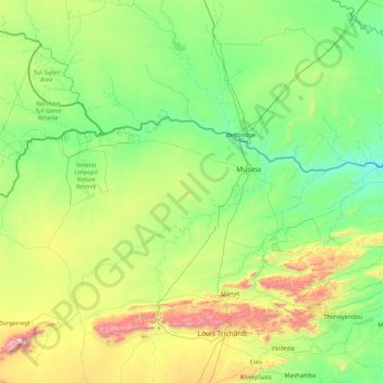
Name: Musina Local Municipality topographic map, elevation, terrain.
Average elevation: 2,270 ft
Minimum elevation: 1,168 ft
Maximum elevation: 6,696 ft
Make a donation
Gear up for your next adventure:
As an Amazon Associate, this site earns from qualifying purchases at no extra cost to you.
Other topographic maps
Click on a map to view its topography, its elevation and its terrain.
Thohoyandou
South Africa > Limpopo > Vhembe District Municipality > Thulamela Local Municipality
Average elevation: 2,073 ft
Malamulele
South Africa > Limpopo > Vhembe District Municipality > Thulamela Local Municipality
Average elevation: 1,778 ft
Malavuwe
South Africa > Limpopo > Vhembe District Municipality > Thulamela Local Municipality
Average elevation: 1,713 ft
Make a donation
Gear up for your next adventure:
As an Amazon Associate, this site earns from qualifying purchases at no extra cost to you.
Valdezia
South Africa > Limpopo > Vhembe District Municipality > Makhado Local Municipality
Average elevation: 2,418 ft
Mutale
South Africa > Limpopo > Vhembe District Municipality > Thulamela Local Municipality
Average elevation: 3,333 ft
Dzanani
South Africa > Limpopo > Vhembe District Municipality > Makhado Local Municipality
Average elevation: 2,733 ft
Make a donation
Gear up for your next adventure:
As an Amazon Associate, this site earns from qualifying purchases at no extra cost to you.
Nandoni Dam
South Africa > Limpopo > Vhembe District Municipality > Thulamela Local Municipality
Average elevation: 1,650 ft
Manyii
South Africa > Limpopo > Vhembe District Municipality > Makhado Local Municipality
Average elevation: 2,992 ft
Chillas
South Africa > Limpopo > Vhembe District Municipality > Thulamela Local Municipality
Average elevation: 1,460 ft
Mashamba
South Africa > Limpopo > Vhembe District Municipality > Makhado Local Municipality
Average elevation: 1,926 ft
Make a donation
Gear up for your next adventure:
As an Amazon Associate, this site earns from qualifying purchases at no extra cost to you.
Folovhodwe
South Africa > Limpopo > Vhembe District Municipality > Mutale Local Municipality
Average elevation: 1,716 ft
Mtititi
South Africa > Limpopo > Vhembe District Municipality > Thulamela Local Municipality
Average elevation: 1,558 ft
Tshipise
South Africa > Limpopo > Vhembe District Municipality > Mutale Local Municipality
Average elevation: 1,542 ft
Phiphidi Waterfall
South Africa > Limpopo > Vhembe District Municipality > Thulamela Local Municipality
Average elevation: 2,562 ft
Make a donation
Gear up for your next adventure:
As an Amazon Associate, this site earns from qualifying purchases at no extra cost to you.
Thohoyandou
South Africa > Limpopo > Vhembe District Municipality > Thulamela Local Municipality
Average elevation: 2,073 ft
Thohoyandou
South Africa > Limpopo > Vhembe District Municipality > Thulamela Local Municipality
Average elevation: 2,073 ft
Phiphidi Waterfall
South Africa > Limpopo > Vhembe District Municipality > Thulamela Local Municipality
Average elevation: 2,562 ft
Make a donation
Gear up for your next adventure:
As an Amazon Associate, this site earns from qualifying purchases at no extra cost to you.
Malamulele
South Africa > Limpopo > Vhembe District Municipality > Thulamela Local Municipality
Average elevation: 1,778 ft
Nandoni Dam
South Africa > Limpopo > Vhembe District Municipality > Thulamela Local Municipality
Average elevation: 1,650 ft
Jimmy Jones, South Africa
South Africa > Limpopo > Vhembe District Municipality > Thulamela Local Municipality
Average elevation: 1,798 ft
Masisi
South Africa > Limpopo > Vhembe District Municipality > Mutale Local Municipality
Average elevation: 1,250 ft
Make a donation
Gear up for your next adventure:
As an Amazon Associate, this site earns from qualifying purchases at no extra cost to you.
Mtititi
South Africa > Limpopo > Vhembe District Municipality > Thulamela Local Municipality
Average elevation: 1,558 ft
Phiphidi Waterfall
South Africa > Limpopo > Vhembe District Municipality > Thulamela Local Municipality
Average elevation: 2,572 ft
Dzanani
South Africa > Limpopo > Vhembe District Municipality > Makhado Local Municipality
Average elevation: 2,733 ft
Make a donation
Gear up for your next adventure:
As an Amazon Associate, this site earns from qualifying purchases at no extra cost to you.
Beit Bridge
South Africa > Limpopo > Vhembe District Municipality > Musina Local Municipality
Average elevation: 1,483 ft
Chavani
South Africa > Limpopo > Vhembe District Municipality > Makhado Local Municipality
Average elevation: 2,444 ft
Thononda
South Africa > Limpopo > Vhembe District Municipality > Mutale Local Municipality
Average elevation: 4,249 ft
Make a donation
Gear up for your next adventure:
As an Amazon Associate, this site earns from qualifying purchases at no extra cost to you.