
Grad Požega topographic map
Interactive map
Click on the map to display elevation.
About this map
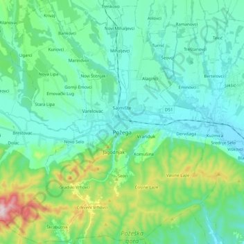
Name: Grad Požega topographic map, elevation, terrain.
Location: Grad Požega, Požega-Slavonia County, 34000, Croatia (45.26777 17.56777 45.40587 17.75298)
Average elevation: 728 ft
Minimum elevation: 417 ft
Maximum elevation: 1,952 ft
Požega (elevation: 152 m (499 ft)) is located in the south-western part of the Valley of Požega, or Požega basin, in Croatian: Požeška kotlina. This fertile valley has been important since the antiquity - its Roman name was Vallis Aurea, meaning "golden valley".
Other topographic maps
Click on a map to view its topography, its elevation and its terrain.
Ploštine
Croatia > Požega-Slavonia County > Grad Pakrac
Ploštine, Grad Pakrac, Požega-Slavonia County, Croatia
Average elevation: 495 ft
Velika
Croatia > Požega-Slavonia County
Velika, Općina Velika, Požega-Slavonia County, 34330, Croatia
Average elevation: 876 ft
Požega
Croatia > Požega-Slavonia County > Požega
Požega, Grad Požega, Požega-Slavonia County, 34000, Croatia
Average elevation: 715 ft
Brekinska
Croatia > Požega-Slavonia County
Brekinska, Grad Lipik, Požega-Slavonia County, Croatia
Average elevation: 440 ft