
Dunsmuir Reservoir 31-018 Dam topographic map
Interactive map
Click on the map to display elevation.
About this map
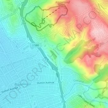
Name: Dunsmuir Reservoir 31-018 Dam topographic map, elevation, terrain.
Average elevation: 262 ft
Minimum elevation: 43 ft
Maximum elevation: 715 ft
Alameda County trails, hiking, mountain biking, running and outdoor activities
Other topographic maps
Click on a map to view its topography, its elevation and its terrain.
Oakland Casting Club pools
United States > California > Alameda County > Oakland
Average elevation: 518 ft
Reinhardt-Redwood Regional Park
United States > California > Alameda County > Oakland
Average elevation: 958 ft