
Make a donation
Gear up for your next adventure:
As an Amazon Associate, this site earns from qualifying purchases at no extra cost to you.
Claremont Canyon topographic map
Click on the map to display elevation.
Make a donation
Gear up for your next adventure:
As an Amazon Associate, this site earns from qualifying purchases at no extra cost to you.
About this map
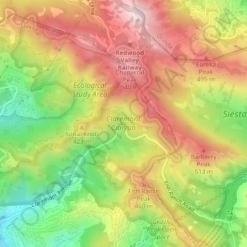
Name: Claremont Canyon topographic map, elevation, terrain.
Average elevation: 1,204 ft
Minimum elevation: 449 ft
Maximum elevation: 1,870 ft
Alameda County trails, hiking, mountain biking, running and outdoor activities
Make a donation
Gear up for your next adventure:
As an Amazon Associate, this site earns from qualifying purchases at no extra cost to you.
Other topographic maps
Click on a map to view its topography, its elevation and its terrain.
Oakland Casting Club pools
United States > California > Alameda County > Oakland
Average elevation: 518 ft
Reinhardt-Redwood Regional Park
United States > California > Alameda County > Oakland
Average elevation: 958 ft
Dunsmuir Reservoir 31-018 Dam
United States > California > Alameda County > Oakland
Average elevation: 262 ft