
Make a donation
Gear up for your next adventure:
As an Amazon Associate, this site earns from qualifying purchases at no extra cost to you.
Arboretum topographic map
Click on the map to display elevation.
Make a donation
Gear up for your next adventure:
As an Amazon Associate, this site earns from qualifying purchases at no extra cost to you.
About this map
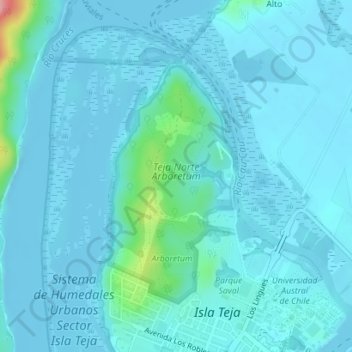
Name: Arboretum topographic map, elevation, terrain.
Average elevation: 39 ft
Minimum elevation: -26 ft
Maximum elevation: 404 ft
Make a donation
Gear up for your next adventure:
As an Amazon Associate, this site earns from qualifying purchases at no extra cost to you.
Other topographic maps
Click on a map to view its topography, its elevation and its terrain.
Make a donation
Gear up for your next adventure:
As an Amazon Associate, this site earns from qualifying purchases at no extra cost to you.
Villa California
Chile > Región de Los Ríos > Provincia de Valdivia > Valdivia
Average elevation: 89 ft
Villa Endesa
Chile > Región de Los Ríos > Provincia de Valdivia > Valdivia > Villa Endesa
Average elevation: 26 ft
Cutipay
Chile > Región de Los Ríos > Provincia de Valdivia > Valdivia > Cutipay
Average elevation: 115 ft
Make a donation
Gear up for your next adventure:
As an Amazon Associate, this site earns from qualifying purchases at no extra cost to you.