
Make a donation
Gear up for your next adventure:
As an Amazon Associate, this site earns from qualifying purchases at no extra cost to you.
Cayumapu topographic map
Click on the map to display elevation.
Make a donation
Gear up for your next adventure:
As an Amazon Associate, this site earns from qualifying purchases at no extra cost to you.
About this map
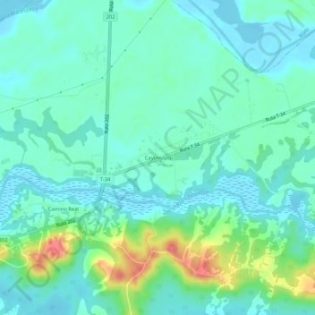
Name: Cayumapu topographic map, elevation, terrain.
Average elevation: 56 ft
Minimum elevation: -7 ft
Maximum elevation: 230 ft
Make a donation
Gear up for your next adventure:
As an Amazon Associate, this site earns from qualifying purchases at no extra cost to you.
Other topographic maps
Click on a map to view its topography, its elevation and its terrain.
Parque Municipal Guillermo Harnecker
Chile > Región de Los Ríos > Provincia de Valdivia > Valdivia > Villa Endesa
Average elevation: 26 ft
Make a donation
Gear up for your next adventure:
As an Amazon Associate, this site earns from qualifying purchases at no extra cost to you.
Parque Oncol
Chile > Región de Los Ríos > Provincia de Valdivia > Valdivia
Ocupa el costado sur del cerro Oncol junto al santuario de la naturaleza Carlos Anwandter del río Cruces. La cima del cerro alcanza una altitud de 715 m s. n. m., y se encuentra a solo 5 kilómetros de la costa.
Average elevation: 1,207 ft