Geolocate

Tiller topographic map

Click on the map to display elevation.

About this map

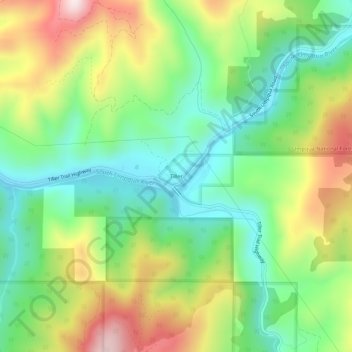
Name: Tiller topographic map, elevation, terrain.

Location: Tiller, Douglas County, Oregon, 97484, United States (42.90872 -122.97128 42.94872 -122.93128)

Average elevation: 1,647 ft

Minimum elevation: 971 ft

Maximum elevation: 2,733 ft

Douglas County trails, hiking, mountain biking, running and outdoor activities

Other topographic maps

Click on a map to view its topography, its elevation and its terrain.

Elkton

United States > Oregon > Douglas County

According to the United States Census Bureau, the city has a total area of 0.26 square miles (0.67 km2), of which, 0.23 square miles (0.60 km2) is land and 0.03 square miles (0.08 km2) is water. The elevation is 141 feet (43 m).

Average elevation: 312 ft

Elk Creek

United States > Oregon > Douglas County

Average elevation: 1,181 ft

Galesville Reservoir

United States > Oregon > Douglas County

Average elevation: 2,149 ft

Oakland

United States > Oregon > Douglas County

Average elevation: 564 ft

Yoncalla

United States > Oregon > Douglas County

Average elevation: 456 ft

Green

United States > Oregon > Douglas County > Green

Average elevation: 574 ft

Gear up for your next adventure:

🪑Portable Camp Table - Compact table for campsite meals
🧴Hand Sanitizer - Keep hands clean while hiking
🔦Powerful Headlamps - Ultra-bright hands-free lighting for night navigation
🪶Wildlife Field Guides - Learn animal tracking and species ID
🧣Hiking Neck Gaiter - Multi‑use neck protection for outdoor weather

As an Amazon Associate, this site earns from qualifying purchases at no extra cost to you.