
Yoncalla topographic map
Click on the map to display elevation.
About this map
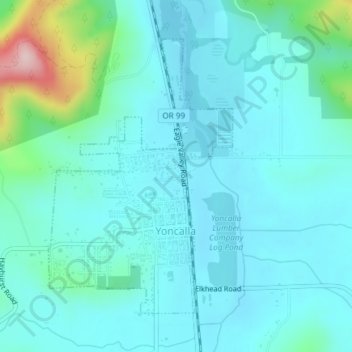
Name: Yoncalla topographic map, elevation, terrain.
Location: Yoncalla, Douglas County, Oregon, United States (43.59212 -123.29695 43.61321 -123.27736)
Average elevation: 456 ft
Minimum elevation: 318 ft
Maximum elevation: 1,184 ft
Douglas County trails, hiking, mountain biking, running and outdoor activities
Other topographic maps
Click on a map to view its topography, its elevation and its terrain.