
Wareham topographic map
Click on the map to display elevation.
Wareham
Wareham was first settled in 1678 by Europeans as part of the towns of Plymouth and Rochester. It was officially incorporated in 1739 and named after the town of Wareham in England. Because of its geography, Wareham's early industry revolved around shipbuilding and the related industries. It also served as a resort town, with many smaller resorts scattered around the town, especially in Onset. Like Sandwich, its waterways, especially Buttermilk Bay, were considered as possible pathways for the Cape Cod Canal. Although the canal proper goes through Bourne and Sandwich, the southern approach to Buzzards Bay passes just south of the peninsulas that make up the topography of the town.
About this map
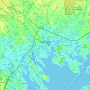
Name: Wareham topographic map, elevation, terrain.
Location: Wareham, Plymouth County, Massachusetts, United States (41.68954 -70.78169 41.82578 -70.61663)
Average elevation: 39 ft
Minimum elevation: -23 ft
Maximum elevation: 217 ft
Plymouth County trails, hiking, mountain biking, running and outdoor activities
Other topographic maps
Click on a map to view its topography, its elevation and its terrain.
West Meadow
United States > Massachusetts > Plymouth County > West Bridgewater
Average elevation: 95 ft
Miles Standish Park
United States > Massachusetts > Plymouth County > Duxbury
Average elevation: 49 ft
Kenberma
United States > Massachusetts > Plymouth County > Hull > Nantasket Beach
Average elevation: 7 ft
Manomet Heights
United States > Massachusetts > Plymouth County > Plymouth > Manomet
Average elevation: 33 ft
Marshfield Center
United States > Massachusetts > Plymouth County > Marshfield
Average elevation: 112 ft
Mill Pond
United States > Massachusetts > Plymouth County > Duxbury > Miles Standish Park
Average elevation: 66 ft
Fresh Pond
United States > Massachusetts > Plymouth County > Plymouth > Cedar Bushes
Average elevation: 46 ft
Crescent Beach
United States > Massachusetts > Plymouth County > Mattapoisett
Average elevation: 16 ft
Great Herring Pond
United States > Massachusetts > Plymouth County > Plymouth > Cedarville
Average elevation: 79 ft
Arthur Thurbur Land
United States > Massachusetts > Plymouth County > Duxbury > Baileys Corner
Average elevation: 59 ft
Scotland Estates
United States > Massachusetts > Plymouth County > Bridgewater
Average elevation: 92 ft
Eldon B. Kieth Field
United States > Massachusetts > Plymouth County > Brockton
Average elevation: 131 ft
Cedarville Landing
United States > Massachusetts > Plymouth County > Plymouth
Average elevation: 52 ft
Peddocks Island
United States > Massachusetts > Plymouth County > Hull > Fort Andrews
Average elevation: 3 ft
Green Harbor River
United States > Massachusetts > Plymouth County > Marshfield > Green Harbor
Average elevation: 7 ft
Indian Heights
United States > Massachusetts > Plymouth County > Wareham > Indian Heights
Average elevation: 26 ft
Cranberry Village
United States > Massachusetts > Plymouth County > Carver > Cranberry Village
Average elevation: 98 ft
Marshfield Hills
United States > Massachusetts > Plymouth County > Marshfield > Marshfield Hills
Average elevation: 95 ft
Marshfield Hills
United States > Massachusetts > Plymouth County > Marshfield
Average elevation: 95 ft