
Lofoten topographic map
Interactive map
Click on the map to display elevation.
About this map
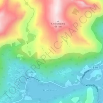
Name: Lofoten topographic map, elevation, terrain.
Location: Lofoten, Vågan, Nordland, Norvège (68.33301 14.66634 68.33311 14.66644)
Average elevation: 761 ft
Minimum elevation: 0 ft
Maximum elevation: 2,162 ft
Other topographic maps
Click on a map to view its topography, its elevation and its terrain.
Røssnesvågen
Røssnesvågen, Sørland, Værøy, Nordland, 8063, Norvège
Average elevation: 10 ft
Stuorgiedde - Storjorda
Stuorgiedde - Storjorda, Hamarøy, Nordland, 8275, Norvège
Average elevation: 138 ft
Melnes
Norvège > Nordland > Misvær - Miedasværrda
Melnes, Misvær - Miedasværrda, Bodø, Nordland, 8108, Norvège
Average elevation: 335 ft
Festvågen
Norvège > Nordland > Henningsvær > Festvåg
Festvågen, Festvåg, Henningsvær, Vågan, Nordland, Norvège
Average elevation: 200 ft
Bognássje - Bognes
Bognássje - Bognes, Hamarøy, Nordland, 8275, Norvège
Average elevation: 164 ft