
Juliaca topographic map
Click on the map to display elevation.
Juliaca
Juliaca is a large trade center for goods and services, and is considered the financial capital of the Puno region. Trade is its principal economic activity, comprising 26.5% of the Labor force. In 2008, Juliaca had 15,439 commercial establishments, which amounts to 41% of trade done in the Puno region. It is the commercial hub for the La Rinconada high-altitude city of informal gold mining.
About this map
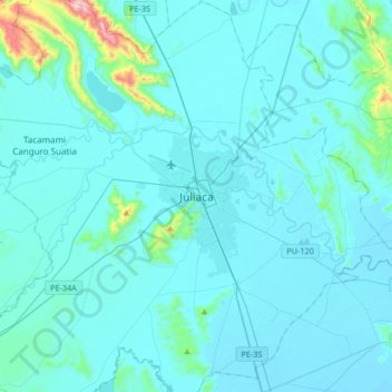
Name: Juliaca topographic map, elevation, terrain.
Location: Juliaca, Province of San Román, Puno, 21100, Peru (-15.65323 -70.29562 -15.33323 -69.97562)
Average elevation: 12,667 ft
Minimum elevation: 12,513 ft
Maximum elevation: 14,751 ft
Other topographic maps
Click on a map to view its topography, its elevation and its terrain.
Lake Titicaca
Lake Titicaca has a surface elevation of 3,812 m (12,507 ft). The "highest navigable lake" claim is generally considered to refer to commercial craft. Numerous smaller bodies of water around the world are at higher elevations. For many years, the largest vessel afloat on the lake was the 2,200-ton (2,425 U.S.…
Average elevation: 12,697 ft
Lake Titicaca (Peruvian sector)
Lake Titicaca has a surface elevation of 3,812 m (12,507 ft). The "highest lake" claim is generally considered to refer to commercial craft. Numerous smaller lakes around the world are at higher elevations. For many years, the largest vessel afloat on the lake was the 2,200-ton (2,425 U.S. tons), 79 m (259 ft)…
Average elevation: 13,163 ft