
Magdalen Islands topographic map
Click on the map to display elevation.
About this map
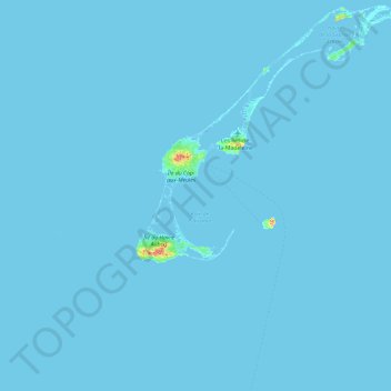
Name: Magdalen Islands topographic map, elevation, terrain.
Average elevation: 3 ft
Minimum elevation: -10 ft
Maximum elevation: 525 ft
Other topographic maps
Click on a map to view its topography, its elevation and its terrain.
Les Îles-de-la-Madeleine
Canada > Quebec > Urban agglomeration of Les Îles-de-la-Madeleine
Average elevation: 7 ft
Île de la Grande Entrée
Canada > Quebec > Urban agglomeration of Les Îles-de-la-Madeleine > Les Îles-de-la-Madeleine > Grande-Entrée
Average elevation: 7 ft
Île du Havre Aubert
Canada > Quebec > Urban agglomeration of Les Îles-de-la-Madeleine > Les Îles-de-la-Madeleine
Average elevation: 13 ft
Île du Havre aux Maisons
Canada > Quebec > Urban agglomeration of Les Îles-de-la-Madeleine > Les Îles-de-la-Madeleine > Havre-aux-Maisons
Average elevation: 10 ft
Magdalen Islands
Canada > Quebec > Urban agglomeration of Les Îles-de-la-Madeleine > Grosse-Île
Average elevation: 3 ft